Looking for the Forests of Lebanon
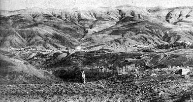
ABOUT 5000 years ago, we are told by archaeologists, a Semitic tribe swept in out of the desert and occupied the eastern shore of the Mediterranean and established the harbor towns of Tyre and Sidon. On the site of another such harbor town is Beirut, which today is the capital of the republic of Lebanon. You can see it from a high point on the Lebanon Mountains overlooking the Mediterranean Sea.
These early Semites were Phoenicians, who found their land a mountainous country with a very narrow coastal plain and little flat land on which to carry out the traditional irrigated agriculture as it had grown up in Mesopotamia and Egypt. We may believe that as the Phoenician people increased, they were confronted with three choices: (1) of migration and colonization, which we know they did; (2) of manufacturing and commerce, which we know they did; and (3) of cultivation of slopes, about which we have hitherto heard very little.
Here was a land covered with forests and watered by the rains of heaven, a land that held entirely new problems for tillers of soil who were accustomed to the flat alluvial valleys of Mesopotamia and the Nile. As forests were cleared either for use or for commerce, slopes were cultivated. Soils of the slopes eroded then under heavy winter rains as they would now. Here under rain-farming, tillers of soil for the first time encountered severe soil erosion and the problem of establishing a permanent agriculture on sloping lands.
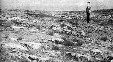
This hillside in Trans-Jordan was once covered with a layer of productive soil. Sheet erosion probably removed most of the topsoil during the first century of use. Gullies then began to form. As the gullies grew thicker and deeper, practically all topsoil and subsoil were removed from the entire slope. Man has put this land back almost to the state it was in when nature first started to build soil on it.
|
We find as we read the record written on the land in this fascinating region, tragedy after tragedy deeply engraved on the sloping land where efforts to hold back the life-giving soil were developed to high stages of refinement and were later allowed to fall into ruin. We saw many slopes that were once covered with forests where the trees had been cut and the land cleared and cultivated. Soil began forthwith to erode under seasonal winter rains; efforts were made to control erosion by constructing walls across the slopes, of which we see ruins here and there today. For one reason or another, these measures failed, and the soil mantle shifted down slope under the action of progressive erosion. As the fine-textured soil was washed away leaving loose rocks at the surface, tillers of the soil piled them together to make cultivation about them the easier. In these cases the battle with soil erosion was definitely a losing one.
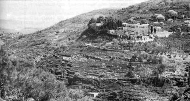
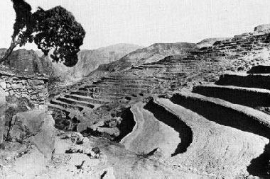
Rock-walled bench terraces in Lebanon that have been in use for thousands of years. The construction of terraces of this type would cost from $2,000 to $5,000 per acre if labor was figured at 40 cents per hour. Such expensive methods of protecting land are practical only where people have no other land on which to raise their food.
|
Elsewhere we found how the battle with soil erosion had been won by the construction and maintenance of a remarkable series of rock-walled terraces from the bases to the crests of slopes, like fantastic staircases. At Beit Eddine in the mountains of Lebanon east of Beirut, we round the slopes terraced even up to grades of 76 per cent. At wages of 40 cents per hour it would cost $2000 to $5000 an acre to build such structures on 50 to 75 per cent slopes. These vast works, an arresting monument to the labor of tillers of soil throughout thousands of years, show the length to which a people will go to save their soils when necessity for food requires it.
Some say we cannot afford to build terraces at such fabulous costs; but these people did so, and we would do as much if it were necessary to survive. We spent more than 300 billion dollars to defend our land against foreign foes during World War II; we would do as much to save our land from erosion if it were necessary. Our war effort averaged more than $150 for every acre of land in continental United States and more than $700 for every acre of cultivated land. Who says we cannot afford it? But, fortunately, by the science of conservation we can save our soils for sustained use at a mere fraction of the cost or defending our land from invasion by the army or planes of an enemy country.
Cedars still grow in Lebanon when given a chance. This is part of one of the four small groves that still exist. It is in the grounds of a monastery and is protected from goat grazing by the stone fence.
|
The mountains of ancient Phoenicia were once covered by the famous forests of cedars of Lebanon. An inscription on the temple of Karnak as translated by Breasted, announces the arrival in Egypt before 2900 B.C. of 40 ships laden with timber of cedar out of Lebanon. You also recall that it was King Solomon, nearly 3000 years ago, who made an agreement with Hiram, King of Tyre, to furnish him cypress and cedars out of these forests for the construction of the temple at Jerusalem. Solomon supplied 80,000 lumberjacks to work in the forest and 70,000 to skid the logs to the sea. It must have been a heavy forest for such a woods force. What has become of this famous forest that once covered nearly 2000 square miles?
This forest was protected in Roman times to grow timber for the Roman fleet as told by inscribed monuments. In the mountains of Lebanon, many monuments were found marked with the letters, "H.D.S." Their meaning was not understood until a stone was found and carried to the museum of the American University at Beirut. The inscription is interpreted to read: "Emperor Hadrian Augustus, Forest Boundary" (Emp. Hdn. Aug. Definitie Silvarum), indicating that in the time or Emperor Hadrian the boundaries of these forests were marked for protection.
But today only four small groves of this famous Lebanon cedar forest are left, the most important or which is the Tripoli grove of trees in the cup of a valley. An examination of the grove revealed some 400 trees of which 43 are old veterans or wolf trees. As we read the story written in tree rings, it appears that about 300 years ago the grove had nearly disappeared with no less than 43 scattered veterans standing. These trees with wide-spreading branches had grown up in an open stand. About that time a little church was built in their midst that made the grove sacred; a stone wall was built about the grove to keep out the goats that grazed over the mountains. Seeds from the veterans fell to the ground, germinated and grew up into a fine close-growing stand of tall straight trees that show how the cedars or Lebanon will make good construction timber when grown in forest conditions.
Such natural restocking also shows that this famous forest has not disappeared because or adverse change of climate, but that under the present climate it would extend itself if it were safeguarded against the rapacious goats that graze down every accessible living plant upon these mountains.
As we read in the Holy Lands records of decline and ruin and oblivion of great empires of the past, we were moved by the ineffable sadness and tragedy of man's failures to find a lasting adjustment to his land resources. Time after time as I pondered tragic ruins or great centers of power and culture and the even more tragic ruins of the lands that supported these teeming centers of population, the question would come to mind: Must our fair country of America rise to great power and strength only to decline and fall, because we fail to find a solution to this age-old problem of a permanent source of abundant and adequate food? Have we the intelligence -- have we the will to establish here a lasting nation where the dream of liberty for all is planted? Here is a challenge to the perennial youth of our land!
China's Sorrow
Before proceeding to Cyprus and North Africa, let's take a look at China, whose civilization probably arose somewhat later than that which developed in the Near East and was partly influenced by it. Mixed agriculture, irrigation, the ox-drawn plow, and terracing of slopes are notable similarities in the two regions.
It was in China, while I was engaged in an international project for famine prevention in 1922-27, that the full and fateful significance of soil erosion was first burned into my consciousness.
During an agricultural exploration into regions of North China seriously affected by the famine of 1920-21, I examined the site where the Yellow River in 1852 broke from its enormous system of inner and outer dikes. As we traveled across the flat plains of Henan we saw a great flat-topped hill looming up before us. We traveled on over the elevated plain for seven miles to another great dike that stretched across the landscape from horizon to horizon. We mounted this dike and, behold! there lay before us the Yellow River, the Hwang Ho, a great width of brown water flowing quietly that spring morning into a tawny haze in the east.
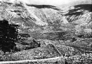
These huge gullies indicate the severity of soil erosion in the deep, and once fertile loessial soils of Northern China. Millions of acres have been cut up like this and are now almost worthless.
|
A brisk chilly wind tugged at our clothing, as we contemplated this scene of tremendous implications. Here lay the river known as China's Sorrow for thousands of years, apparently harmless, in a channel fully 40 to 50 feet above the plain of the great delta. This gigantic river had been lifted up off the plain over its entire 400-mile course across its delta and had been held in this channel by the hand labor of men, without machines or engines, without steel cables or construction timber and without stone. The longer I pondered this awe-inspiring scene, the more was I amazed at the magnitude of the accomplishment of millions of Chinese farmers literally with their bare hands and carrying-baskets, who through thousands of years had built here a stupendous monument to human cooperation and the will to survive. I became oblivious of the chill of the wind that kept tugging at my clothes, lost in wonder and admiration of the nameless and unsung heroes who had fought the battle of floods with this tremendous dragon of a river since the days of Ta-Yu, nearly 4000 years ago, and had lost and won time and again.
But why should this battle with the river have to be endless? Any relaxation of vigilance lets the river break over its dikes, calling for herculean and cooperative work of hundreds of thousands of farmers to put the river back again in its channel. Then suddenly it dawned upon me that the river water was brown with silt, heavily laden with soil that was washed out of the highlands of the vast drainage system of the Yellow River. As the flood waters of China's Sorrow reached the gentler slope of the delta (one foot to the mile) the current slowed down and began to drop the load of silt. Deposits of silt in turn lessened the capacity of the channel to carry flood waters and called on the farmers threatened with angry floods to build up the inner and outer dikes yet higher and higher, year after year.
There was no end to this demand of the river if it were to be confined between its dikes. Final control of the river so heavily laden with silt was hopeless; yet hopeful millions of farmers toiled on.
In 1852, the yellow-brown waters of the Hwang Ho broke out of its elevated channel to seek another way to the sea. It had emptied into the Yellow Sea, where it usurped the old outlet of the Shai River. This time the river broke over its dikes near Kaifeng, Honan, and wandered to the northeast over farm lands, destroying villages, smothering the life out of millions of humans and discharged into the Gulf of Chihli, 400 miles north of its former outlet. China's Sorrow in its rage had refused to be lifted any higher off its plain. Hundreds of thousands of farmers had been defeated. Silt -- its unending accumulation in the channel of the Yellow River -- had defeated them, valiant as they were.
Silt -- silt -- silt! As we were aroused by the tugging of the cold wind, we turned away determined to learn where this silt came from, even up to the head waters.
In a series of carefully planned agricultural explorations we discovered the source of the silt that brought ruin to millions of farmers in the plains. In the Province of Shansi we found how the line of cultivation was pushed up slopes, following the clearing away of forests. Soils formerly protected by a forest mantle were thus exposed to the dash of summer rains, and soil erosion began a headlong process of land destruction and filling of streams with soil waste and detritus.
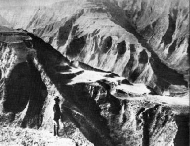
These bench terraces in Shansi Province, China, illustrate the extent to which some Chinese farmers have gone to conserve the remaining soil on their hillsides.
|
Without a basis of comparison, we might easily have misread the record as written there on the land. But temple forests, preserved and protected by the Buddhist priests, gave me and my Chinese associates a remarkable chance to measure and compare the rates of erosion within these forests and on similar slopes and soils that had been cleared and cultivated. The story of these fascinating studies is too long to include in this paper; it is reported in the Proceedings of the Pan-Pacific Science Congress, Tokyo, 1926.
In brief, my Chinese scientific associates (T.I. Li, C.T. Ren, C.O. Lee and others) and myself carried out a series of soil erosion experiments during rainy seasons of 3 years in which we measured the rate of runoff and erosion by means of runoff plots within temple forests and out on farm fields under cultivation or abandoned because of erosion. It was on such slopes as these that we got for the first time in soil erosion studies, experimental data on such comparisons. Here too, we found how the Yellow River had become China's Sorrow, for we found that runoff and erosion from cultivated land were many times as great as from temple forests, whereas they caused heavy losses of soil from cultivated land.
It was clear that if the farmers of the delta plain were ever to be safeguarded from the mounting perils of the silt-laden Yellow River, the source of the silt must be stopped by measures of erosion control.
Further west in the midst of the famous and vast loessial deposits of North China, we found in another exploration in the Province of Shensi, how an irrigation system that was first established in 246 B.C. had been put out of use by silt. Here again silt was the villain in the tragedy of the land. Silt was undoing the anxious and unending labor of the Chinese to establish a lasting adjustment to their land. We sought out the origin of the silt that had brought an end to an irrigation project which had fed the sons of Han during the Golden Age of China. The origin was found in areas where soil erosion had eaten out of the land gargantuan gullies 600 feet deep, that were advancing headward into the great mantle of fertile loessial soil. One may see remnants of terraces that were in use before the landscape was riddled by huge gullies. It was while contemplating such scenes that I resolved to challenge the conclusions of the great German geologist, Baron von Richthofen, and of Ellsworth Huntington, that the decadence of North China was due to desiccation or pulsations of the climate.
Temple forests gave the clue; they demonstrated beyond a doubt that the present climate would support a generous growth of vegetation capable of preventing erosion on such a scale. Human occupation of the land had set in motion processes of soil wastage that were in themselves sufficient to account for the decadence and decline of this part of China, without adverse change of climate. In other words, soil erosion unless controlled, will undermine a civilization. I could see that it had already done so, and, unless ways to control it were found, it would bring desolation to others including my own country.
It was in the presence of such tragic scenes on a gigantic scale that I resolved to run down the nature of soil erosion, which had proved to be the insidious enemy of civilization and to devote my lifetime to study of ways to conserve the lands on which mankind depends. Out of this experience grew a series of scientific studies in China during the years 1923-27, as reported elsewhere, which were transferred to the United States in 1927 and have been incorporated in erosion and stream-flow investigations of the U. S. Forest Service and later in our movement for land conservation in the United States, under the leadership of Dr. H. H. Bennett, Chief of the Soil Conservation Service.
Soil Waste in Ancient Cyprus
Let's now go back and follow the westward course of civilization from the Holy Lands through North Africa and on into Europe. We shall first stop in Cyprus where we found the land-use problems of the Mediterranean epitomized in a comparatively small area. If one wishes to study land use in the Mediterranean region he will find in Cyprus a summary of all major problems brought together within a small area -- an introduction to, or a summary of, problems of land use of the lands surrounding the Mediterranean Sea.
In the plain of Mesaoria is written a telling record in and about a Byzantine church. The church on the outskirts of the village of Asha in eastern Cyprus is surrounded by a graveyard and its wall. The alluvial plain now stands 8 feet above the level of the churchyard as we measured it. On entering the church we stepped down 3 feet from the yard level to the floor of the church; but inside the church we noted that low pointed arches were blocked off, and new arches cut for doors and windows. The aged vestryman told us that about 30 years ago a flood from the plain had filled the church with water and left 2 feet of silt on the floor. Rather than clean it out, a new stone floor had been laid over the silt deposit. Thus, 8 plus 3 plus 2 equals 13 feet, the height of the present alluvial plain above the church floor. From these measurements we concluded that the plain had filled in not loss than 13 feet, very probably more, with erosional debris washed off the drainage slopes. This church proclaims silently and eloquently the progressive wastage of soils of the surrounding hill lands that have been cultivated up steep gradients.
Across North Africa
We shall now continue westward along the northern coast of Africa into Tunisia, and Algeria. Here we read the record of the granary of Rome in North Africa during the Empire, by surveying a cross section across North Africa from the Mediterranean to the Sahara Desert, from 40 inches of rainfall to 4 inches, from Carthage on the coast to Biskra at the edge of mysterious Sahara.
In Tunisia we found that it rains in the desert of North Africa in winter time now as it did in the time of Caesar, who in 44 B.C. complained of how a great rainstorm with wind had blown over the tents of his army encampment and flooded the camp. It rains hard enough to produce flash floods in the wadis. At one place muddy water swept across the highway in such volume that we decided to wait until the next day until the flash flow had gone down before proceeding.
As we make a rapid survey of land use across Tunisia and Algeria from the Mediterranean coast to the edge of the Sahara, through the center of what was the granary of Rome, we shall begin at Carthage, the principal city of North Africa in Phoenician times.
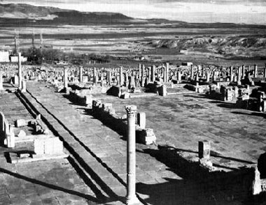
In the middle distance may be seen the ruins of the ancient Roman city of Cuicul. It was a rich and prosperous city in North Africa when that region was known as the "granary the Roman Empire." Note that the ruin of the land, as seen in the distance and foreground, is almost as complete as the ruin of the city.
|
We stood on the site of ancient Carthage, one of the colonies of Phoenicia that grew to be great and powerful -- the city that produced Hannibal and became a dangerous rival of Rome. In 146 B.C. at the end of the Third Punic War, Scipio destroyed Carthage, but out of the doomed city he saved 28 volumes of a work on agriculture written by a Carthaginian by the name of Mago, who was recognized by the Greeks and Romans as the foremost authority on agriculture in the Mediterranean. These works of Mago were translations in the existing works of such Roman writers on agricultural subjects as Columella, Varro, and Cato. This incident tells us that the traditions of conserving soils and waters that we believe were first discovered on the slopes of ancient Phoenicia had been brought by their colonists to North Africa; we suspected these measures furnished the basis of the great agricultural production that was so important to the Romans during the Empire.
Over a large portion of the ancient granary of Rome we found the soil washed off to bed rock and the hills seriously gullied from overgrazing. The valley floors are usually still cultivated but are still eroding in great gullies fed by accelerated storm runoff from barren slopes. This was in an area that once supported many great cities in Roman times.
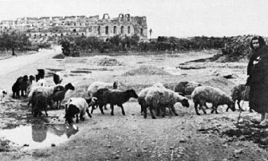
This small flock of scrawny sheep graze on the scant vegetation that may be found near the ruins of Cuicul. This is about the only productive use the land now has; the gullied hillsides in the distance do not even support enough vegetation for that.
|
We found at Djemila the ghosts of Cuicul, a city that was once great and populous and rich but later was covered completely, except for about 3 feet of a single column, by erosion debris washed off slopes of surrounding hills. For 20 years French archaeologists had been excavating this remarkable Roman city and unearthed great temples, two great forums, splendid Christian churches, and great warehouses for wheat and olive oil. All this had been buried by erosional debris washed from the eroding slopes above it. The surrounding slopes once covered with olive groves are now cut up with active gullies.
The modern village that falls heir to this once beautiful Roman city houses only a few inhabitants. The flat lands are still farmed to grain but the slopes once planted to olives are bare and eroding and wasting away. What is the reason for this astounding decline and ruin?
Timgad, Lost Capital of a Lost Agriculture
Further to the south we stopped to study the ruins of another great Roman city of North Africa, Thamugadi, now called Timgad. This city was founded by Trajan in the first century A.D., laid out in symmetrical pattern and adorned with magnificent buildings, with a forum embellished by statuary and carved porticoes, a public library, a theater to seat some 2500 persons, 17 great Roman baths, and, if you please, with marble flush toilets for the public. After the invasion of the nomads in the seventh century had completed the destruction of the city and dispersal of its population, this great center of Roman culture and power was lost to knowledge for 1200 years. It was buried by the dust of wind erosion from surrounding farm lands until only a portion of Hadrian's arch and 3 columns remained like tombstones above the undulating mounds to indicate that once a great city was there.
The ruins of Timgad -- an ancient Roman city built during the first century A.D. The few huits seen in the center background now house about 300 inhabitants, which is all the eroded land will support. Note that the eroded hills in the background are almost as desolate as the ruins of the city.
|
Since discovery of the site, the French Government has been excavating this great center for 30 years and has disclosed remarkable examples of building, of art, and of ways of living during Roman times in North Africa, all supported by the agriculture of the "Granary of Rome." The mosaics that lined the public baths were beautiful in design. Within the city we found ruins of a great bakery with its many grist mills turned by slaves to grind the wheat that grew on the plains. But today this great center of power and culture of the Roman empire is desolation; it is represented by a modern village of only a few hundred inhabitants who live in squalid structures, the walls of which are for the most part built of stone quarried from the ruins of the ancient city.
We saw also where water erosion cut a gully down into the land and exposed an ancient aqueduct that supplied water to the city of Timgad from a great spring some 3 miles away. Within and surrounding Timgad, we studied remarkable ruins of great olive presses where today there is not a single olive tree within the circle of the horizon.
On the plain of Tunisia we came upon in El Jem, the ruins of a great coliseum, second only in size to that of Rome, for the amusement of a city in a populous region. It was built to seat some 65,000 people, whereas it would be difficult to find 5000 persons today within this district. The ancient city now lies buried around the coliseum and a sordid modern village is built on the buried city.
What was the cause of the decadence of North Africa and the decline of its population? Some students have suggested that the climate changed and became drier, forcing people to abandon their remarkable cities and works. But Gsell, the renowned geologist who studied this problem for 40 years, challenged the conclusion that the climate has changed in any important way since Roman times. So Director Hodet, of the Archaeological Excavations at Timgad, decided as an experiment to plant olive trees on an unexcavated portion of the city where there would be no possibility of sub-irrigation. He planted young olive trees in the manner prescribed in Roman literature, watering them in the following two long dry summer seasons. These olive trees are thriving, indicating that where soils are still in place, olive trees will grow today probably very much as they did in Roman times.
Ruins of the amphitheatre at the former city of Thyusdrus, in Tunisia, which would seat 60,000 people. Today, only a few thousand people inhabit this area. the small flock of sheep in the foreground are a fair indication of the land's ability to support life.
|
On the plains about Sfax, ruins of olive presses were found by early travelers, but no olive trees. An experiment was decided upon 40 years ago to plant olive trees there, and they grew. Now more than 150,000 acres are planted to olive trees, and their products support thriving industries in the modern city of Sfax. These plantings indicate that the climate of today, as far as production of olives is concerned, is not unlike that of Roman times; in other words, that the climate has not become drier in a significant degree since Roman times.
Other students of this baffling problem have suggested that pulsations of climate with intervening dry periods have taken place, sufficient to blot out the civilization of North Africa. Such undoubtedly might have been the case, but at Sousse we found telling evidence on this point in an olive grove that has survived since Roman times. These olive trees are at least 1500 years old, we were informed. I was interested in the way these trees were planted -- in basins bordered by banks of earth with ways of leading in unabsorbed storm runoff from higher ground. We passed along this area at a time of heavy rains which showed just how this method had worked since the trees were first planted. If there have been pulsations of climate since Roman times this grove should show that the drier periods were not sufficiently severe to kill the olive trees. We conclude that it does not seem probable that either a progressive change of climate or pulsations of climate account for the decadence of North Africa. We must seek other causes for this colossal tragedy.
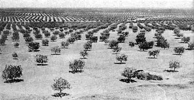
This large grove of olive trees are thriving on the plains near Sfax, Tunisia. The scattered groves of this kind that may be found in North Africa today show that the climate is still suitable for agriculture where productive soil is still on the land.
|
On hillsides between Constantine and Timgad, we found written on the land a record that indicates what has happened to soils of the granary of ancient Rome. We found some hills which, according to the botanists, were covered with savanna vegetation of scattered trees and grass. Vegetation had conserved a layer of soil on these hills for unknown ages. With the coming of a grazing culture brought in by invading nomads of Arabia, erosion was unleashed by overgrazing of the hills. We can see written here on the landscape how the soil mantle was washed off the upper slopes to bed rock. Accelerated runoff from the bared rock cut gullies into the upper edge of the soil mantle, working it down hill as if a great rug were being pulled off the hills, and depositing material at lower levels. The accumulation of torrential flows during winter storms is cutting great gullies through the alluvial plains just as it does in New Mexico, Arizona, and Utah of our own country. The effect of this is to lower the water table, bringing about the effects of desiccation without reduction in rainfall. In this manner has the country been seriously damaged and its capacity to support a population much reduced. Unleashed and uncontrolled soil erosion is sufficient to undermine a civilization, as we found in North China and as seems to be true in North Africa as well.
The Dry Lands of North Africa
We traveled across North Africa southward toward the Sahara Desert into zones of less and less rainfall. Beyond the cultivated area in Roman times was a zone devoted to stock raising on a large scale. Thousands of cisterns were built in Roman or pre-Roman times to catch storm runoff from the land to store it for outlying villages and for watering herds of livestock during the dry summer seasons. Many of these cisterns were being cleaned out and repaired by the French Government before World War II, to use for the same purpose as they were used for in ancient times. And the French Government was going the Romans one better because of the advantage in steel reinforced concrete construction. We looked upon one of the modern cisterns four times as large as any Roman cistern, with a capacity of 100,000 cubic feet. This cistern was filled in two years and now waters the herds of semi-nomads who inhabit this portion of North Africa.
Still farther toward the desert about 70 miles south of Tebessa we found a remarkable example of ancient measures for the conservation of water At some time in the Roman or possibly pre-Roman period, peoples of this region built check dams to divert storm water around the slope -- in canals that the French are now cleaning out again -- to spread upon a remarkable series of bench terraces. This area of unusual interest raises a number of puzzling questions which we are not yet able to answer. If these terraces were cultivated to crops in times past they are the best evidence we have that climate has become drier since they were first built. But if they were built for spreading water to increase forage production for grazing herds then, as the French are using them today, they are not evidence for an adverse change of climate. This evidence alone could leave us in doubt, but other evidence would indicate that water spreading was most used here for crops.
This region of North Africa is similar to the Navajo country in the United States where in recent years our Soil Conservation Service has developed measures for spreading storm water on alluvial valley floors to increase forage growth for herds of Navajo sheep. It would be interesting to know the date and the reason for building these terraces. They may indicate that with Roman occupation of North Africa the native tribes were driven beyond the border of the Roman Empire and were forced to devise these refined measures for conservation and use of water in a dry area; or they may indicate that North Africa was so densely populated that it was necessary to use these refinements in the conservation of water to support the population on the margins of a crowded region. Whatever may be the answers to these questions, the French Government during our visit in North Africa in 1939, was in the course of restoring these ancient practices of diverting storm water with check dams around slopes in canals to spread it upon the gentle slopes that had been flattened by a remarkable series of bench terraces.
We passed through the Saharan Atlas mountain range by a narrow valley and into the mysterious Sahara Desert that spreads out toward the horizon as a faint blue sea. Salmon-colored sands form restless dunes that wander hither and yon in a lifeless landscape. At the north wall of the Sahara Desert, near the foot of the mountain wall we came upon the oasis of Biskra. We found the oasis a refreshing contrast to the glare of the desert. This oasis is nourished by sweet water from great springs issuing at the foot of limestone mountains.
The importance of an oasis in North Africa is measured not by the number of its inhabitants, but rather by the number of its date-palm trees. The oasis of Biskra has 250,000 date palms that furnish crops of delicious dates, as we know from personal experience, that are the chief articles of trade in the markets and the chief article of diet of the people.
We have now completed a transect across North Africa from 40 inches of rainfall on the coast to 4 inches at Biskra -- across the granary of Rome -- and have seen how great cities were built and grew up in this fertile region supported chiefly by crops of grain and olive oil. We have told how these great cities were abandoned and the former dense population dispersed; how the cities were buried in the overwash of erosional debris from eroding hills and by the dust of wind erosion from surrounding farm lands, and lost to knowledge for a period of 1200 years. We have noted the evidences that this decline and decadence of North Africa was neither due to a progressive adverse change of climate nor to pulsations of climate, but was due to the breakdown of an agriculture of remarkable refinements which arose out of colonization by the Phoenicians who, we believe, brought from ancient Phoenicia the solutions to problems of conserving soils and waters encountered in their mountainous homeland.
Soil erosion by water and by wind has so damaged this once fair province of the Roman Empire that its capacity to support people has been much reduced. The soils have been washed off the hills and deposited in the valleys, where they may still be cultivated but are still eroding, as we saw by great gullies that cut through alluvial valley fills.
While the land has been seriously damaged, as you can see written on landscape after landscape, the country is still capable of far greater than its present production. In Roman times a high stage of conservation of soils and waters was reached with an intensive culture of orchards and vineyards on the slopes, and intensive grain-growing in the valleys. All this depended on efficient conservation and use of the rainfall. We find numerous references to such practices in the literature of the time. But as nomads swept in out of the desert, their extensive and exploitive grazing culture replaced these highly refined measures of land use and let them fall into disuse and ruin. Erosion was unleashed on its destructive course, and the capacity of the land to support people was seriously reduced.
The veteran student of North Africa, Prof. Gautier, answered my query as to whether the climate of North Africa had changed since Roman times, in the following way: "We have no evidence to indicate that the climate has changed in an important degree since Roman times; but," he said, "the people have changed." We conclude that the decline of North Africa is due to a change in a people and more especially to a change in culture and methods of use of land that replaced a highly developed and intensive agriculture and that allowed erosion to waste away the land and to change the regime of waters.
Next
Part 1
Foreword
Introduction
Freedom Bought and Sold for Food
Graveyard of Empires
In Egypt's Land
On the Trail of the Israelites
The Land of Milk and Honey
Across Syria
The Hundred Dead Cities
Part 2
Looking for the Forests of Lebanon
China's Sorrow
Soil Waste in Ancient Cyprus
Across North Africa
Timgad, Lost Capital of a Lost Agriculture
The Dry Lands of North Africa
Part 3
A Word About Land Use in Italy
Torrent Control in the French Alps
Intensive Land Use in France
How the Dutch Farm the Ocean Floor
A Glance at England
The New World
The Record of Our Lands
Danger Signs in America
The Way to an Enduring Agriculture
Lessons from the Old World
The Eleventh Commandment
Back to the Small Farms Library Index